Paddling the Spanish River: A Guide
by Mike Henry

Introduction
Thousands of canoeists on Ontario’s Spanish River have paddled through the worlds largest red and white pine wilderness without knowing it. But lately the global significance of the forest around the Lower Spanish River is gaining recognition, and now part of it is now a provincial park. Dense pine blankets the steep shores for about two days of paddling; north of the elbow to the confluence with the Wakonnasin. Much of that, an area about the size of Killarney park, has never been logged. But this ancient forest also stretches back from the shores of the river that canoeists know, across small often unnamed lakes and rugged trail-less hills. Literature about paddling the Spanish provides little or no information about connecting the popular canoe route on the river to the interior lakes. This report describes the details of a trip that we undertook in the fall of 1998 to explore and evaluate one of these routes. If you want to know more about the area read our 2018 a report showing a proposed expansion to Rushbrook Provincial Park.
Getting There
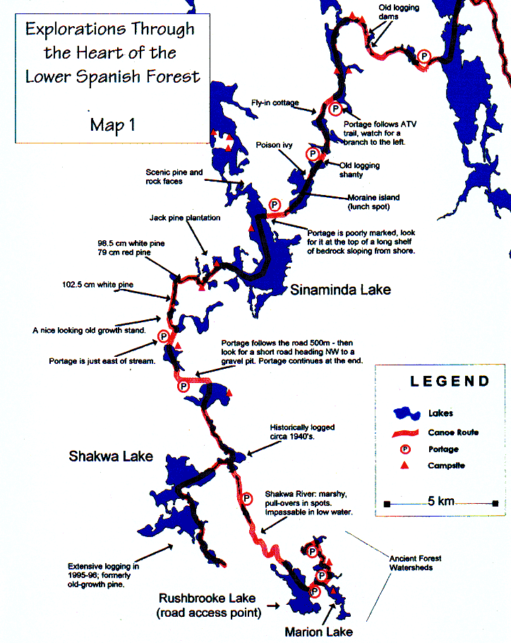
The Spanish River can be accessed at a number of different points by car, train, or by float plane. The most popular route is from Duke Lake on the east arm of the Spanish, to Agnew Lake, near Webwood (several local shuttle services are available). You can also begin your trip at Biscotasing lake on the west arm, which is accessible by rail service, float plane or car (see shuttle services, below). Other access points for shorter trips include the elbow (accessible by car) or Pogamasing lake (accessible by float plane). If you choose to explore the interior, the route to the Spanish is only recommended for experienced paddlers because routes, portages and campsites are not clearly marked. However, the route is recommended for those seeking adventure and Agnew Lake Lodge offers a shuttle service to Rushbrook and other lakes on request. You can access some of the interior lakes from logging roads. The best road access point is Rushbrook Lake; north Shakwa and Marion also have road access. Finding your way on the labyrinth of logging roads can be tricky; bring good maps, and ask local advice if you want to be sure.
To Get to Rushbrook or Marion Lake from Highway 17:
-
Turn north on Agnew Lake Road at the west end of Webwood. Set your car’s odometer to 0.
-
At 6 km turn left (follow the sign for black bear camp) onto west branch road.
-
At 46.5 km, turn right on a major road. This is Charcoal Road.
-
At 53.7 km you will come to a bridge. Continue straight across the bridge;
-
At 67.5 km you will reach Shakwa road on the left, which leads to Rushbrook Lake and also to extensive logging around Lower Shakwa Lake.
-
To reach Rushbrook Lake take the the left turn then travel a few kilometres and watch for a small lane to the right (46.7205 -81.912) which leads to Rushbrook Lake landing.
-
Or to reach Marion Lake stay on Charcoal Rd past the Shakwa Rd turnoff and watch for a small lane to the left (north) which leads to Marion Lake (km 67.7). The lane is small and easy to miss, but is only about 200 meters from the Shakwa Road turnoff, and just before Charcoal Rd passes a large wetland. The Marion turnoff is at 46.7186, -81.888. This is also a good landing, and the road is passable, but maybe not for low clearance vehicles.
-
Be careful not to block trailer turnarounds – it may look like a perfect parking spot, but trailers need them to back into to turn around. Instead park along the side of the lane where it widens out near the Lake
From Rushbrook to the Spanish River
The outlet from Rushbrook runs into a broad marsh, with many winding channels – allow an extra hour or so to negotiate these, and generally try to stay to the left. Soon you will reach Shakwa River, and as you paddle up this it will become shallower and more rocky and you will need to make several short portages and pull-overs. Negotiating these streams is potentially the most frustrating part of the route to the Spanish, at least in low water, but also beautiful and far off the beaten track, and worth a little extra time to enjoy. These streams may be impassable in very low water. You will need to carry around the old dam on Shakwa Lake’s outlet, which has raised the water level of the lake several feet. Despite this, much of the shoreline of the lake remains pristine, characterised in many areas by beautiful bedrock shores, small islands, and sheer cliffs. Some extensive clearcuts as well as shelterwood logging are visible on the south-west shore.
The portage to Wensley lake is reached by paddling to the road access at the north end of the lake, and portaging roughly 1 km west on the road. Keep an eye on the right side for a side-road leading off which quickly leads to a small gravel pit. An ATV trail continues at the back right side, running through a cedar fen to the lakeshore. Some interesting species growing out of the sphagnum here include creeping snowberry, goldthread, and bugleweed.
Wensley Lake is pretty, and mostly surrounded by red and white pine, some of which was logged in the 1940’s. The portage to Landry is just east of the stream at the north end of Wensley. Again Landry is a pretty lake, with some logging and some old growth including some giant pine trees.
Pull over a bridge to Sinaminda – for some time the left shore of Sinaminda is young jack pine plantation, the right shore is nice white pine, though it may have had some logging. Campsites on Sinaminda were generally poor. The north end of Sinaminda seems more scenic, but we didn’t explore it, preferring instead to portage to Gilden, Lake, and then to Dennie Lake, both beautiful lakes.
For two days now you follow the path of the glaciers and the old-time loggers. You will follow poorly marked portages, some quite old where trees have started to overgrow the old axe blazes that mark trails worn deep into the ground. Look for the portage from Sinaminda to Gilden Lake at the top of a long slope of bedrock – use your map to get you close, since it has little to mark it as a portage. Half-way across the trail to Gilden Lake a glacial “erratic” boulder sits on a broad rock face where it was dropped by a glacier ten thousand years ago. Gilden Lake has some long narrow islands, moraines plowed up by the glaciers.
Near the portage from Gilden to Dennie, there’s an old logging shanty, about 20 m east of the landing. Most of the forest here, of course, is logged out – we didn’t see much ancient forest again until we were on the Spanish River.
The portage to Little Pogamasing follows an ATV trail – start by following it to the right, then after a few minutes, watch for a branch to the left that leads to Little Pogamasing. Expect to get your feet wet.
Pogamasing River is an exceptional historical tour of the old river driving days, with many old dams that were used to build up a head on this small river, for the spring log drive. You follow the loggers down Pogamasing creek, which they used to drive the logs they cut from the lakes in behind. The old-time loggers used water for their own ends, like beavers. They built up a head of water behind the dams, then let it go in a flood along with the logs. Rivers and creeks were the “roads” of the lumbermen up until about 40 years ago.
Pogamasing Lake is a beautiful Lake, despite having been mostly logged out in the past. There is a great deal of pine around it, and you’ll find the odd sand bar or gravel spit if you paddle near shore. There are a few cabins on the lake. Pogamasing is an ojibway word meaning “Where water flows over gravel.” Our camp on Pogamasing was an exceptional site on a long sandy spit. But expect to have sand in your food and your tent for a few days after.
Continue down the next branch of Pogamasing creek. At the head of the creek, behind a tall dam, the shores were littered with dead logs, left behind by the men of the log drives.
The River
We were greeted to the Spanish by a freight train. This is part of the great transcontinental railway from 1870, the “national dream.” The forest near the railway now is young birch and jack pine, and small red and white pine crown the hills. In a few hours, though, when we left the railway behind, we were welcomed back to the wilderness by mature red and white pine forest, and we camped under a white pine on Spanish lake.
Turning around the elbow and you will enter fast water on the ride to the graveyard rapids. The graveyard, named for the dangerous days of driving logs down the river, has a few short portages, and some of it can be run (especially in low water) with caution; as its name implies some of the rapids cannot be run. It’s a very beautiful series of ledges, with steep banks of pine. Just below one of these (“the ledge”) there’s a recent surface fire on the north shore that burnt along the ground, killing the shrubby understory of balsam fir and cedar, but leaving the overstory of pine alive.
At the base of the graveyard rapids is an old logging shanty on the east shore, and a log graveyard – at the bottom of the river! The river-bottom here is littered with old sawlogs, mostly small ones cut for pulp.
There is an excellent campsite at the base of cedar rapids, where you can listen to boulders shifting on the riverbed as you fall asleep. If you’re feeling adventurous, go ashore two kilometres down river from our campsite, to hike in a stand of old growth along the shore of the Spanish. This stand was part of a large allocation for logging but now it will be protected in the new Provincial Park.The stand age is about 140 years, it is a beautiful stand with good hiking potential from the river. It is close the river, but it can be rough initially because of some moss covered boulders. There are views towards the river, and over the hills in behind – but in both cases is it obstructed by at least some trees.
The ‘royal ride’ most of the way to the confluence with the Wakonnasin offers both exceptional paddling, and beautiful ancient pine forest on the steep hills.
Grey Owl wrote in the 1930’s about the wilderness that he knew from many years of fur-trapping, and even then he lamented it’s disappearance. In 1936 he wrote “The Wilderness should now no longer be considered as a playground for vandals, or a rich treasure trove to be ruthlessly exploited for the personal gain of the few – to be grabbed off by whoever happens to get there first.” Wilderness like Grey Owl once saw will soon be gone. Near the Lower Spanish River there’s still a bit of the wilderness that he knew.
Some recommended doing some reading before you plan a trip on the Spanish River it would be a good idea to read what others who went before had to say. Some books that include the Spanish are:
Ron Reid and Janet Grand, 1986. Canoeing Ontario’s Rivers. Sierra Club Books, San Francisco. 320 pages.
Kevin Callan, 1996. Up the Creek: A Paddler’s guide to Ontario. Boston Mills Press, Erin, Ontario. 126 pages.

Marion and Rushbrook lakes are part of a watershed that is entirely pristine, and they are largely surrounded by old growth pine forest that is about 150 years old. Scattered trees that survived a major fire 150 years ago are over 300 years old. The portages have recently been clearly signed and are now easy to find, as are several campsites. Portages join Marion lake to Rushbrook Lake and to Fiona Lake. The latter provides access to a remote and beautiful watershed dominated by old growth red and white pine – from Fiona lake canoeist can portage to a chain of five lakes, then back to Rushbrook. There are campsites suitable for groups: on the island of Marion Lake (sometimes has trash), and on ‘Happy Little Cheesebun Lake,’ the next in the chain after Fiona Lake. The portage to Rushbrook is just south of the outlet stream, and roughly parallels the stream through a beautiful old-growth valley.
The Rushbrook-Marion canoe area is a premier wilderness canoe area in old-growth pine forest, and it is virtually undiscovered. It is unlikely at the time of writing that you would see any other paddlers on this small chain of lakes surrounded by pristine old pine forest. Portages in this area were cleared in spring 2018. This chain of lakes is a lovely place to spend one or more days before going to Shakwa and lakes beyond. The area is under lease to Domtar but is not currently allocated, and is part of a proposed Provincial Park expansion. Rushbrook is a beautiful lake, and the outlet on the north end of the lake also provides access to Shakwa River, and Shakwa Lake – the beginning of the route to the Spanish River.
The Interior: Ancient Watersheds
Maps